Your Epic Guide to the Best Waterfalls, New Zealand: West Coast Edition
Here is the eleventh edition of my epic guide to the best waterfalls in New Zealand! This one is written for the West Coast region. Here are twelve wicked waterfalls on the West Coast, and everything you need to know when visiting. Here we go, from northernmost to southernmost:
Four Rivers Plain
If it wasn’t obvious, the Four Rivers Plain is in the northwestern corner of the South Island, and it’s here that the Buller River, Matiri River, Mangles River and Mātakitaki Rivers all meet. And right here, on this plain, is our first West Coast waterfall – Mangatini Waterfall.

1. Mangatini Falls
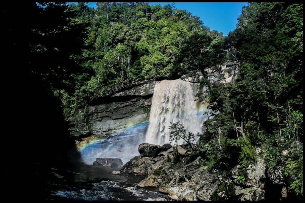
General Location: Mangatini Falls sits in the upper part of the South Island’s West Coast, only a little bit inland. Nearest Civilisation: Mangatini Falls is half an hour’s drive north of the town of Westport, 32 kilometres or 20 miles. Immediate Surroundings: Mangatini Falls sits on the Ngākawau River and the track there takes you along the river and through the Ngākawau Gorge.
Waterfall Height: Mangatini Falls is 25 metres tall. Waterfall Viewpoints: Although there are other waterfalls seen during your first hour on the track, the first view of Mangatini Falls is from the suspension bridge, not before! There’s a lookout just after the bridge from where you can also view Mangatini Falls. You can scramble down to the bottom, if you’re careful, as well.
Getting There: You’ll need to take Charming Creek North Walkway to Mangatini Falls. Track Distance: Charming Creek North Walkway is 5.5 kilometres one way (3.5 miles). Walk Time: The walk to Mangatini Falls is two hours, one way.
Swimming: There’s no easy swimming access at Mangatini Falls so it is not really recommended here. Dogs: Dogs need to be under control at Mangatini Falls.
Wheelchairs and Prams: The track used to be a tramway, so it’s mostly flat and wide. Just bear in mind that wheelchairs and prams may struggle to cross the suspension bridge, so you may have to only go that far before turning around. In parts there are railway sleepers so it can get quite bumpy.
Go, Because: Go, because there are lots of tunnels on this walkway, making it a fun adventure for all ages! It used to be a tramway and you will also see old coal mining and milling sites.
Something Extra: Your something extra is to continue along Charming Creek Walkway, because once past Mangatini Falls suspension bridge there is a lookout, then a tunnel, then it goes on for a few more kilometres, along Charming Creek (with more suspension bridges). At the end is the Charming Creek Coal Mine, Mumm’s Mill, and Watson’s Mill. The track is also a bike track, so consider taking a bike if you are fit and able! Last Updated: November, 2024.
Paparoa National Park
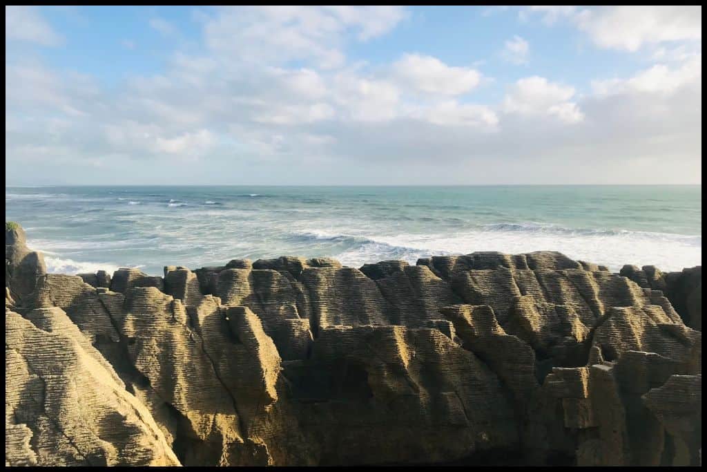
Paparoa National Park is another of our incredible national parks and it’s full of West Coast rainforest, rivers, rugged wilderness and rock formations. One of the gateways in is Punakaiki, home to the Pancake Rocks, and home to our next waterfall, too.

2. Hanging Waterfall / Te Miko Waterfall, Paparoa National Park
General Location: Paparoa National Park sits on the West Coast and has excellent rock formations as well as rainforest and rivers. Nearest Civilisation: Te Miko Waterfall is only 2.5 kilometres (1.5 miles), or a five minute drive from the coastal settlement of Punakaiki, made famous by the Pancake Rocks (which are a network of coastal limestone rocks, all stacked and layered just like a stack of pancakes). Immediate Surroundings: Te Miko Waterfall is on Te Miko Beach, flowing out of a stream onto the beach.
Waterfall Height: Te Miko Waterfall is 7 metres tall. Waterfall Viewpoints: You can view Te Miko Waterfall from the base – which is the beach.
Waterfall Name: Te Miko Waterfall is named for Te Miko, the Maori name for the headland nearby. Miko translates to ‘nīkau seedling’. The nīkau is a native palm that is abundant in this area.
Getting There: Take the Truman Track to view Te Miko Waterfall. Track Distance: It’s 500 metres to Te Miko Waterfall, and 500 metres back. Walk Time: It’s a fifteen minute walk to Te Miko Waterfall, one way.
Swimming: Te Miko Waterfall is too small to swim in. Dogs: Dogs are not allowed at Hanging Waterfall. Wheelchairs and Prams: Bridges and stairs make access to Te Miko Waterfall uneasy for wheelchairs and prams.
Go, Because: Go, because this is a good excuse for a walk on the beach (on top of going to see a waterfall)! Something Extra: Visit the Pancake Rocks and walk the short Pancakes Rock Track which will give you the best vantage points of these unique limestone stacks and the tidal blowhole, as well. Last Updated: November, 2024.
Greymouth & Surrounds
Greymouth is the biggest town on the West Coast and somewhere you will almost certainly be passing through, whether you’ve taken Lewis Pass or Arthur’s Pass through to the West Coast, or travelled up from the south. And you won’t even have to go far from town to see this next waterfall!

3. Coal Creek Falls

General Location: Coal Creek Falls are just north of Greymouth out on the West Coast of the South Island. Nearest Civilisation: The town of Greymouth is a quarter of an hour away by car, 10 kilometres, or 6 miles. Immediate Surroundings: Coal Creek Falls sit on Coal Creek.
Waterfall Height: Coal Creek Falls is 7 metres tall. Waterfall Viewpoints: You will see the Falls from the top as you approach and can descend down the staircase to see the bottom of it. Waterfall Name: Coal Creek Falls are named after Coal Creek, which pays homage to the coal mining history of the area.
Getting There: Coal Creek Track will get you to Coal Creek Falls. Track Distance: The walk to and from Coal Creek Falls is 3.6 kilometres, or 2.2 miles. Walk Time: It’s an hour return to walk to and from Coal Creek Falls.
Swimming: There’s good swimming at Coal Creek Falls. Dogs: Dogs are not permitted at Coal Creek Falls. Wheelchairs and Prams: People have found the walk to Coal Creek Falls quite doable even with prams.
Go, Because: Go, because this is a great little addition to your West Coast itinerary; being so close to Greymouth, you are almost certainly going past. Something Extra: Head to nearby Point Elizabeth for the Point Elizabeth Coastal Walkway – and views out toward the Alps and Paparoa Mountains. Last Updated: November, 2024.
4. Carew Creek Falls / Carew Falls

General Location: Carew Creek Falls is located about a third of the way down the South Island’s West Coast, inland from Greymouth. Nearest Civilisation: The town of Greymouth to Carew Creek Falls is a three quarter of an hour’s drive, 44 kilometres, or 27 miles. From Moana, the settlement around the lake from Carew Creek Falls, it’s half an hour (35 kilometres, 22 miles).
Immediate Surroundings: Carew Creek Falls is on Carew Creek and just on the shores of Lake Brunner, within the Lake Brunner Scenic Reserve. Waterfall Height: Carew Creek Falls is 30 metres tall. Waterfall Viewpoints: You can view Carew Creek Falls from the base.
Waterfall Name: Carew Creek Falls are named after the Carew family. Getting There: The track to Carew Creek Falls is Carew Falls Walk. Track Distance: Carew Falls walk is 1.8 kilometres, or a mile return.
Walk Time: The return walk to Carew Creek Falls will take you three quarters of an hour. Swimming: There’s a great swimming pool at Carew Creek Falls. Dogs: Dogs are not allowed at Carew Creek Falls.
Wheelchairs and Prams: The track to Carew Creek Falls is not the most suited for wheelchairs and prams. Go, Because: Go, because you’ll see old pipes on the track there that used to be used for hydropower a long time ago.
Something Extra: Something you can do in the nearby settlement of Moana, on the opposite shore of Lake Brunner, is board the scenic TranzAlpine train (where it stops there each time it shuttles between Greymouth and Christchurch). The rail journey traverses Arthur’s Pass and so the mountain views you’ll get on the way back to Christchurch are incredible. It’s one of the best rail journeys in the world! Last Updated: November, 2024.

Lake Kaniere Scenic Reserve
Inland a little way from Hokitika is Lake Kaniere and the Lake Kaniere Scenic Reserve. You’ll be well off the beaten track if you come in from the coast even this far, but the lake – and this next waterfall – are worthy stopping points.
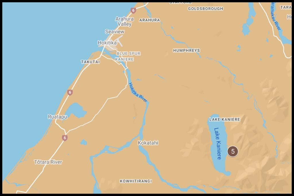
5. Dorothy Falls

General Location: Dorothy Falls sits a third of the way down the West Coast of the South Island, and is near Lake Kaniere. Nearest Civilisation: Dorothy Falls is a half hour drive inland from the town of Hokitika, 25 kilometres away, or 15 miles. Immediate Surroundings: Dorothy Falls is located within Lake Kaniere Scenic Reserve, on Dorothy Creek.
Waterfall Height: Dorothy Falls is 64 metres tall. Waterfall Viewpoints: You can see Dorothy Falls from the road or walk down to the base. Getting There: You can see Dorothy Falls from the road, or follow a short path to the base.
Track Distance: It’s barely a couple of hundred metres to Dorothy Falls. Walk Time: You’ll only need a minute to access Dorothy Falls. Swimming: Yes! You can swim at Dorothy Falls although the pool is not very big.
Dogs: Dogs are not permitted at Dorothy Falls. Wheelchairs and Prams: Wheelchairs and prams will struggle to access Dorothy Falls. Go, Because: Go, because this one is very easily accessed and something else to do if you’re in this remote part of the country!
Something Extra: Lake Kaniere is an awesome fishing spot, if you’re after salmon or trout. Last Updated: November, 2024.
Westland / Tai Poutini National Park
Westland, or Tai Poutini National Park, is an extra special gem in the crown – it’s one of New Zealand’s three World Heritage Sites, and was awarded UNESCO status in 1990. Easy to see why: this is glacier land, and our next waterfall is right at the feet of one of our most accessible glaciers:

6. Trident Creek Falls
General Location: Trident Creek Falls is down the bottom of the West Coast Region, in the Tai Poutini National Park – home to Fox Glacier and Franz Josef Glacier, and somewhere that has been awarded UNESCO status. Nearest Civilisation: Franz Josef Village is a ten minute drive away, 5 kilometres, or 3 miles.
Immediate Surroundings: Trident Creek Falls is located in the Franz Josef Glacier Valley and is at the foot of the Franz Josef Glacier, sitting on the Waiho River. Both the glacier and waterfall are accessed via the same walk. Waterfall Height: Trident Creek Falls is 35 metres tall.
Waterfall Viewpoints: Just the one! Waterfall Name: Trident Creek Falls earns its name because it falls down in three distinct cascades, side by side. Getting There: The track to Trident Creek Falls is the Franz Josef Glacier Walk, or the Kā Roimata o Hine Hukatere Walk.
Track Distance: The walk to Trident Creek Falls and Franz Josef Glacier is 1.7 kilometres return, or 1 mile. Walk Time: Give yourself an hour for the return trip to Trident Creek Falls and the glacier. Swimming: There’s no pool for swimming in at Trident Creek Falls.
Dogs: Dogs are not permitted at Trident Creek Falls. Wheelchairs and Prams: Wheelchairs and prams are generally fine on the Franz Josef Glacier Walk. Go, Because: Go, because you’ll also get to see Franz Josef Glacier, part of what makes this World Heritage Site so special!
Something Extra: Something extra is to experience a heli-hike (a helicopter ride followed by a hike) up on the glacier, a truly unique New Zealand bucket list item. Last Updated: November, 2024.
Haast Pass
Haast Pass, or the Haast Highway, is also known as State Highway 6, and it is our third route through the Southern Alps (alongside Lewis Pass and Arthur’s Pass). It’s a fantastically beautiful route and winds through the Haast River Valley, taking you from the West Coast Region of New Zealand through into Mount Aspiring National Park, in the Otago Region. It’s a place rich in waterfalls: see for yourself!

7. Depot Creek Falls, Haast Pass
General Location: Depot Creek Falls is on the Haast Pass, another of the routes through the Southern Alps. Haast Pass is right down the bottom of the West Coast Region, and takes you through into Wanaka and Mount Aspiring National Park, part of the Otago Region. Nearest Civilisation: The town of Haast is 22 kilometres away, or 13 miles.
Immediate Surroundings: Depot Creek Falls sit on Depot Creek. Waterfall Height: Depot Creek Falls is 10 metres tall. Waterfall Viewpoints: You can see Depot Creek Falls from the road but need to keep your eyes peel as there’s no signage!
Getting There: There’s the option to walk half a minute into the bush for a closer look at Depot Creek Falls. Track Distance: It’s only a couple of hundred metres in to Depot Creek Falls. Walk Time: You’ll need just a minute to walk to and from Depot Creek Falls.
Swimming: There is no swimming access at Depot Creek Falls. Dogs: Dogs will need to be on a leash at Depot Creek Falls. Wheelchairs and Prams: It’s best to view Depot Creek Falls fro the road if you need to use a wheelchair or pram.
Go, Because: Go, because this drive between Haast and Wanaka is full of spectacular scenery and not to be rushed! Something Extra: Just uptake coast from Haast Village is Knights Point Lookout, also a worthy stop, and your opportunity to see some elephant seals. Last Updated: November, 2024.
8. Roaring Billy Falls, Haast Pass
General Location: Roaring Billy Falls is located on the road between Haast and Wanaka – that’s State Highway 6. It crosses the West Coast Region and Otago Region boundary, in the bottom of the South Island. Nearest Civilisation: The village of Haast is a twenty minute drive from Roaring Billy Falls, 30 kilometres, or 19 miles.
Immediate Surroundings: Roaring Billy Falls flow into the Haast River. It is located in Mount Aspiring National Park. Waterfall Height: Roaring Billy Falls are 30 metres tall.
Waterfall Viewpoints: You’ll get to see Roaring Billy Falls from the opposite side of the Haast River. Waterfall Name: Roaring Billy Falls is named for the sound a roaring billy would make when early settlers were preparing a hot drink. Getting There: Take the Roaring Billy Falls Walk to Roaring Billy Falls.
Track Distance: It’s 1 kilometre (0.6 miles) return to and from Roaring Billy Falls. Walk Time: It’s a twenty five minute walk to and from Roaring Billy Falls. Swimming: There is no swimming access to Roaring Billy Falls.
Dogs: Dogs are not permitted at Roaring Billy Falls. Wheelchairs and Prams: The track to Roaring Billy Falls is accessible for everyone. Go, Because: Go, because you’ll get to hear what they sound like, and how they got their name.
Something Extra: A great way to experience the Haast River Valley is to take a river safari up the Haast River, by jet boat! There are some eco jet boat tours offered by a couple of operators in the area that go right up to Roaring Billy Falls and back. Last Updated: November, 2024.
9. Thunder Creek Falls, Haast Pass

General Location: Thunder Creek Falls is on the road between Wanaka and Haast (Haast Pass) and is located in the bottom corner of the South Island. Nearest Civilisation: The village of Haast is three quarters of an hour’s drive away from Thunder Creek Falls, 52 kilometres, or 32 miles. Immediate Surroundings: Thunder Creek Falls is within the bounds of Mount Aspiring National Park and sits on Thunder Creek, in the Haast River Valley.
Waterfall Height: Thunder Creek Falls is 28 metres tall. Waterfall Viewpoints: There is a viewing platform from which to view Thunder Creek Falls. Getting There: There’s a short, signposted walk to Thunder Creek Falls.
Track Distance: The walk to Thunder Creek Falls is just a hundred metres in and a hundred metres back out again. Walk Time: It’s a ten minute return walk to Thunder Creek Falls. Swimming: Thunder Creek Falls are not suitable for swimming in.
Dogs: Dogs are not permitted at Thunder Creek Falls. Wheelchairs and Prams: Thunder Creek Falls is doable for anyone as the path there is short and sealed. Go, Because: Go, because this one’s easy to get to for everyone, and very impressive, too.
Something Extra: A little north of Haast Village is Ship Creek, which is a small 16 hectare marine reserve where Ship Creek meets the coast. There’s two little walks there to see what the entire West Coast may have looked like before it was inhabited. Last Updated: November, 2024.
10. Gates of Haast, Haast Pass
General Location: The Gates of Haast are in the south-western corner of the South Island, on the highway between Haast and Wanaka, West Coast Region and Otago Region. Nearest Civilisation: Haast Village is a three quarters of an hour drive away, at 53 kilometres, or 33 miles.
Immediate Surroundings: The Gates of Haast are rapids more than a waterfall, and they are on the Haast River, in the Haast River Valley. They’re also within Mount Aspiring National Park. Waterfall Height: The Gates of Haast drop down over 4 metres.
Waterfall Viewpoints: There’s a bridge that you will drive over for a view directly over the river. Waterfall Name: The Gates of Haast are so named because they sit where the road crosses the Haast River. Julius von Haast, a German geologist who travelled New Zealand in the 1800’s is who the area is named after.
Getting There: You’ll see them from the highway and do not need to walk anywhere. Track Distance: You can see the Gates of Haast fro the road – it’s where it crosses over the river. Walk Time: You don’t need to walk to see the Gates of Haast.
Swimming: Absolutely not! The sheer volume of water rushing through this part of the river is huge. Dogs: Dogs need to stay in vehicles at the Gates of Haast; this is a main highway.
Wheelchairs and Prams: There is no track at the Gates of Haast; they’re viewed from the car where you pull over to the side of the road. Go, Because: Go, because the power of the water rushing through is loud and really quite impressive.
Something Extra: Make sure you get out of your car as you will have an excellent photo opportunity of the clear, green Haast River pounding its way past the boulders and over the rocks. Last Updated: November, 2024.
11. Diana Falls, Haast Pass
General Location: Diana Falls are located on the drive through Haast Pass, which takes you from Haast on the West Coast down to Wanaka in the Otago Region, down in the southwest corner of the South Island. Nearest Civilisation: The village of Haast is a three quarters of an hour drive away (55 kilometres, or 34 miles). Immediate Surroundings: Diana Falls sits right by (as in, right by) State Highway 6, which is the Haast Highway. You won’t need to walk to this one!
Waterfall Height: Diana Falls are 15 metres tall. Waterfall Viewpoints: There’s a good view of Diana Falls from the bridge, and from the road. Getting There: You don’t need to walk to Diana Falls, just park up and cross the bridge to see them.
Track Distance: There is no official track to Diana Falls as they are visible from the road. Walk Time: You don’t need to walk to Diana Falls. Swimming: Diana Falls does not have swimming access.
Dogs: Dogs will need to stay on a leash as it is a main highway. Wheelchairs and Prams: Wheelchair and pram users can see Diana Falls from the car. Go, Because: Go, because you’ll be driving past this one if you are doing the Haast Highway anyway! Might as well keep your eyes peeled for it.
Something Extra: Just fifteen minutes drive away are the Haast Blue Pools – the one hour long Blue Pools Track will afford you fantastic views of the Makaroroa River, the gorge, and, most importantly, these pools in the most astounding shades of blue, and you must, must visit on your trip up this highway! Last Updated: November, 2024.

12. Fantail Falls, Haast Pass

General Location: Fantail Falls is yet another waterfall along the Haast Highway, which is State Highway 6, the route between Haast Village on the West Coast and the ski resort town of Wanaka in the Otago Region. Nearest Civilisation: Haast Village is a fifty minute drive from Fantail Falls, 58 kilometres, or 36 miles. Immediate Surroundings: Fantail Falls sits on Fantail Creek, just to the side of the Haast River.
Waterfall Height: Fantail Falls is 23 metres tall. Waterfall Viewpoints: There’s a lookout from across the river at Fantail Falls but you can also carefully cross over to the base.
Waterfall Name: Fantail Falls is named after our native bird, the fantail, whose tail is shaped like a fan. The waterfall is also shaped like a fan, which is why the name was chosen. Getting There: The Fantail Falls Walk gets you to Fantail Falls.
Track Distance: It’s three hundred metres return to and from Fantail Falls. Walk Time: It’ll just take you five minutes to get to Fantail Falls and back. Swimming: There is no decent swimming in Fantail Creek but the Haast River is shallow enough to cross so good for a paddle, at least.
Dogs: Dogs are not permitted at Fantail Falls. Wheelchairs and Prams: The track to Fantail Falls is accessible for everyone. Go, Because: Go, because Fantail Falls is a great stopping point along the highway and a very picturesque one, at that! The Haast River is a clear bluey-green and oh-so-pretty.
Something Extra: Keep an eye out for the little stacked piles of rocks (rock cairns) that people make there! Last Updated: November, 2024.
From Mangatini Falls at the tippy top of the region, down to Fantail Falls at the end of the West Coast side of the Haast Highway, each waterfall is an experience all of its own and deserve to be on the plans for your next trip down here!