
Where Are The Best Beaches In The Bay of Plenty, New Zealand?
The Bay of Plenty – rather obviously, according to the name — has plenty of great beaches from which to choose. From long, surfy stretches to calm harbour spots, this region is one of the best for its coast. Here’s a breakdown of the best beaches in the region; I have grouped them by area so that you can pull this up next to a map when planning your trip.
Best Beaches near Tauranga

⛱️ Waihī Beach
General Location: Waihī Beach is located just at the base of the Coromandel Peninsula, at the top of the Bay of Plenty in New Zealand’s North Island. Nearest Civilisation: Waihī Beach is a beachside town all of its own.
Immediate Surroundings: Waihī Beach is tucked into the Bay of Plenty. It’s immediately south of the Orokawa Scenic Reserve and just north of the Bowentown Peninsula, which shelters the entrance into Tauranga Harbour.
Beach Name: Waihī translates to ‘rising water’ and refers to a legend of a historic figure who stopped in the area to dig a hole for a drink, whereupon water rose up. Getting There: Waihī Beach is 9 kilometres (5.5 miles) long and has 12 points of access all along from the beachfront roads.
Vehicle Parking: Waihī Beach is so long and has multiple carparks. Walking Options: Head from the north end of the beach toward Orokawa Bay (Orokawa Bay Walk). It will take you three quarters of an hour each way (and it’s 6 kilometres, or 3.7 miles, return).
Swimming: The swimming at Waihī Beach is really great. Lifeguards patrol during peak season. Surfing: Surfing at Waihī Beach really lends itself to beginners and intermediate surfers.
Dogs: Dogs are allowed off lead at Waihī Beach except for peak times during summer. Amenities: Waihī Beach has multiple public toilets, multiple cafés and eateries, and a playground right on the esplanade featuring a pump track and sandpit and picnic areas (Island View Reserve).
Camping: Tasman Holiday Parks have a couple of campgrounds at Waihī Beach. Freedom camping in self contained campers is permitted in Island View Reserve by Waihī Beach – and two other local reserves along the coast (Athenree and Bowentown).
Go, Because: Waihī Beach is a national favourite, a very long stretch of idyllic white sand coastline, with great surf and patrolled, for swimmers. Lifeguards patrol in summer, and it is considered a really safe swimming spot. Close to Tauranga, but also an easily travelled distance from Auckland city, it’s popular over summer break. The town of Waihī Beach has all amenities, smaller, but distinct, from the nearby, more inland, town of Waihī.
Something Extra: Waihī Beach is a fabulous place to try surfing for the first time. Enrol at Waihī Beach Surf School. Last Updated: May, 2026.
⛱️ Anzac Bay, Bowentown
General Location: Anzac Bay is located at the entrance to the Tauranga Harbour contained within the wide, sweeping Bay of Plenty in the North Island. Nearest Civilisation: Aside from the small settlement of Bowentown at the southern end of the Bowentown Peninsula, Anzac Bay is nearest the town of Waihi Beach – a ten minute drive (7 kilometres, or 4.3 miles away).
Immediate Surroundings: Anzac Bay is tucked into the underside of the Bowentown Peninsula, the outer facing coast of which is the southern end of Waihi Beach. It sits at the mouth of the Tauranga Harbour and its the harbourside position that makes it such a safe and sheltered beach.
Beach Name: Anzac Bay’s name pays tribute to the Australia and New Zealand Army Corps that fought in the first world war. Getting There: Anzac Bay is accessed from Seaforth Road at the southern end of the Bowentown Peninsula.
Vehicle Parking: Yes! There is a carpark at Anzac Bay. Walking Options: There are some great short walks at Anzac Bay. Take half an hour to head to next door Shelly Bay, an equally lovely little swimming cove. Swimming: Yes! Anzac Bay offers sheltered, family-friendly swimming.
Surfing: Anzac Bay does not lend itself to surfing. Dogs: Dogs are welcome at Anzac Bay. Amenities: Anzac Bay has toilets, showers, changing rooms and picnic areas.
Camping: Campers can stay at nearby Bowentown Beach Holiday Park. Go, Because: Anzac Bay is very family friendly, a little less populated than Waihī Beach, a lot calmer in terms of the surf, and a favourite of parents with little ones. There’s lots of grass, shade, no worrying currents or rips, and water flat enough to paddleboard on.
Something Extra: Head up to the Bowentown Lookout, a short ascent that will have you back in under an hour (2 kilometres return, or 1.2 miles). Views into the harbour and out along the coastline are very rewarding. Last Updated: May, 2026.
⛱️ Ōmokoroa Beach
General Location: Ōmokoroa Beach is located within the Bay of Plenty on the North Island’s east coast. Nearest Civilisation: The city centre of Tauranga is nearly a half hour drive from Ōmokoroa Beach, 23 kilometres, or 14 miles).
Immediate Surroundings: Ōmokoroa Beach is located inside the Tauranga Harbour, on the Ōmokoroa Peninsula inside. 1.5 kilometres (1 mile) offshore is Motuhoa Island, also contained within the harbour.
Beach Name: Ōmokoroa translates to ‘place of the long lizard’, in reference to the shape of the Ōmokoroa Peninsula. Getting There: Ōmokoroa Beach is accessed off the main state highway north of the city of Tauranga. Pedestrian access is easy from the beachfront esplanade.
Vehicle Parking: There is vehicle parking available at Ōmokoroa Beach.
Walking Options: Walk the Ōmokoroa Peninsula Loop Track, which is a couple of hours walking – 9 kilometres, or 5.5 miles. Swimming: Swimming is safe and calm at Ōmokoroa Beach because of its inner harbour location.
Surfing: There is no surf at Ōmokoroa Beach. Dogs: Dogs need to be on a lead at Ōmokoroa Beach. Amenities: Ōmokoroa Beach has toilets, changing rooms, a boat ramp, a playground, a domain, a pizzeria and waterfront eateries.
Camping: Ōmokoroa Top 10 Holiday Park is the perfect nearby getaway for campers; alternatively, freedom camping is permitted in Ōmokoroa Domain. Go, Because: It’s calm, it’s a harbourside beach – as opposed to oceanside (Tauranga has both) – and its a good one for families. There’s good walking here, there are nearby gardens, and the swimming is safe.
Something Extra: Although offshore Motuhoa Island is privately owned, the fishing waters around it are fantastic, so take a kayak over and cast a line. Last Updated: May, 2026.
⛱️ Mount Maunganui Main Beach / ‘The Mount‘
General Location: Mount Maunganui Main Beach is located on the North Island’s Bay of Plenty. Nearest Civilisation: Tauranga city centre is an eight minute drive from Mount Maunganui Main Beach – 6 kilometres, or 3.7 miles.
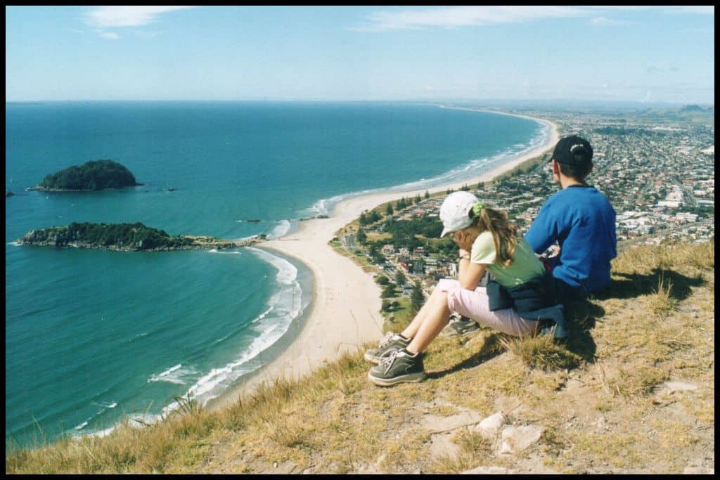
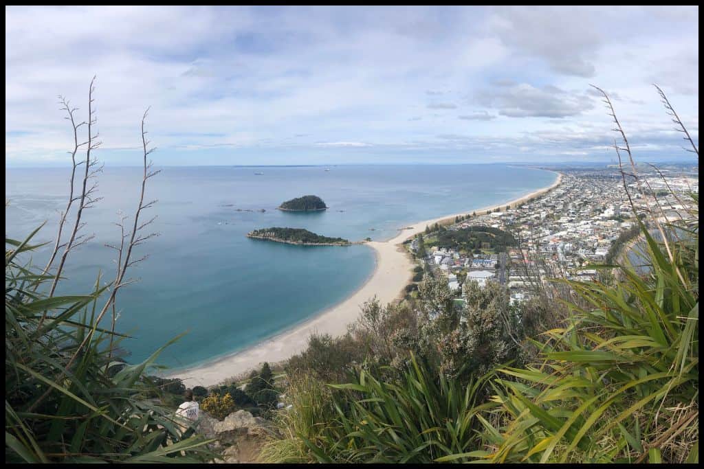
Immediate Surroundings: Mount Maunganui Main Beach is situated on the oceanside shoreline of the peninsula that encloses Tauranga Harbour from the south. At the end of the peninsula is the famous volcano, Mauao (or ‘The Mount’, short for Mount Maunganui.
Moturiki Island sits so close to shore that a man-made bridge connects it with the beach. This one is great for walking and a neat little adventure for little legs.
350 metres off shore is Motuotao Island (Rabbit Island) and this one is a good one to possibly see penguins on as you paddle around, if you have your own watercraft.
Beach Name: Maunganui translates to ‘big mountain’. Getting There: There are twenty access paths down to Mount Maunganui Main Beach as the beach is 3 kilometres long!
Vehicle Parking: There are not enough carparks at Mount Maunganui Main Beach and they’re full by 9am in summer! They are timed parks so that people create spaces as they come and go so you may only be able to stay 1 or 2 hours before you have to move the car. Prepare to walk a little way down to the beach if you have to park on a back street.
Walking Options: Walk the 3 kilometre (1.8 mile) Marine Parade Coastal Path – a very accessible, flat pathway along the coastline. Or take fifteen minutes to stroll out onto Moturiki Island and enjoy the walking out there. Swimming: Swimming is fantastic at Mount Maunganui Main Beach. Lifeguards patrol in peak season.
Surfing: Mount Maunganui Main Beach is suited to surfers of all levels. Dogs: Dogs are not permitted on Mount Maunganui Main Beach. Amenities: Mount Maunganui Main Beach has toilets, showers, changing rooms, a huge playground, a couple of waterfront parks, picnic areas, barbecue areas, the hot pools within walking distance, and waterfront restaurants and cafés in abundance.
Camping: Campers can try to nab a sought after spot at Mount Maunganui Beachside Holiday Park. Go, Because: Mount Maunganui Main Beach was ranked the ‘Best Beach in New Zealand’ by TripAdvisor in 2019 – for the sixth year in a row! – as well as the fourth best beach in the South Pacific – and was said to be one of the top 25 best beaches in the world! Enough said? It’s an absolute favourite. Holidaymakers flock there over New Years in particular – the place to be, if you want to be where the action is.
The Mount is easily climbed and will give you awesome views back across the beach, too. You can get up in three quarters of an hour, and I managed easily in my first trimester with my first pregnancy.
Something Extra: When you return to the bottom, why not soak the muscles in at Mount Hot Pools? Last Updated: May, 2026.

⛱️ Pilot Bay
General Location: Pilot Bay Beach is located in the North Island’s Bay of Plenty, tucked into the Tauranga Harbour. Nearest Civilisation: Pilot Bay Beach is a twelve minute drive from Tauranga’s city centre, 8 kilometres, or 5 miles.
Immediate Surroundings: Pilot Bay Beach is right across the peninsula from Mount Maunganui Main Beach, on the underside. It faces into the Tauranga Harbour and is nestled in at the foot of The Mount (Mauao), so an extremely safe and sheltered beach. Not far offshore is Panepane Point, the southernmost point of Matakana Island which sits between the Tauranga Harbour and the ocean – creating it.
Beach Name: We have another similarly named Pilots Beach down in Dunedin (Otago region) but the two are quite far apart! Getting There: Pilot Bay Beach is easily accessed from the beachfront esplanade.
Vehicle Parking: There are two carparks at Pilot Bay Beach.
Walking Options: Climb The Mount, of course! The summit is a two hour return (4 kilometres, 2.5 miles), but worth it – although there is a smaller loop option lower down as well. Swimming: Gentle, calm swimming at Pilot Bay Beach makes it extremely family friendly.
Surfing: There is no surf at the sheltered Pilot Bay. Dogs: Dogs are not permitted at Pilot Bay Beach. Amenities: Pilot Bay Beach has toilets, a picnic area, a playground and waterfront eateries available.
Camping: There is no campsite at Pilot Bay Beach but the Mount Maunganui Beachside Holiday Park is not far away. Go, Because: Pilot Bay is a good spot to watch the cruise ships come into port – as well as being a safe and calm swimming spot, because of its position on the harbour. There’s lots of grass and a boardwalk, fantastic views, and an all-round good time to be had here.
Something Extra: Wander down to Salisbury Wharf and consider booking a dolphin watching boat tour, or indulge in some fish and chips. Last Updated: May, 2026.
⛱️ Pāpāmoa Beach
General Location: Pāpāmoa Beach is on the North Island’s Bay of Plenty (west coast), a little further down the same stretch of coastline as Mount Maunganui Main Beach. Nearest Civilisation: The city centre of Tauranga is a tiny bit further away from Pāpāmoa Beach, 20 kilometres, or 12 miles.
Immediate Surroundings: Pāpāmoa Beach is further down the coast from Mount Maunganui Main Beach – it’s one continuous stretch. Privately owned Mōtītī Island sits 10 kilometres (6 miles) off the shores of Pāpāmoa Beach. Pāpāmoa Coastal Reserve is located here, too, and the long sand dune stretch here is referred to as the Pāpāmoa Dune Wilderness Area.
Beach Name: Pāpāmoa translates to ‘raised beds for growing vegetables on the flats’. Getting There: Pāpāmoa Beach Road runs the length of Pāpāmoa Beach, providing easy access. Vehicle Parking: Multiple carparks are located at Pāpāmoa Beach.
Walking Options: Take a 90 minute return walk along the Pāpāmoa Shared Pathway Coastal Walk – a 6 kilometre (3.7 mile) boardwalk along the beachfront. Swimming: There is excellent swimming at Pāpāmoa Beach, with lifeguards patrolling during summer. Surfing: Breaks at Pāpāmoa Beach suit all levels of surfers!
Dogs: Dogs are allowed off lead at Pāpāmoa Beach except for near the surf club, foreshore and the sand dunes (Pāpāmoa Dune Wilderness Area). Amenities: Multiple playgrounds, reserves, public toilets, cafés and restaurants are available on the Pāpāmoa Beach waterfront. Camping: Campers can stay at nearby Tasman Holiday Parks Pāpāmoa Beach, although you’ll need to book way in advance for peak summer dates.
Go, Because: Pāpāmoa Beach was given fourth place for the Best Beach in New Zealand in 2019. Kiwis love all 16 kilometres (10 miles) of it. The water is clear, the surf is amazing, it’s patrolled and safe, and lined with all sorts of restaurants and shops.
Something Extra: Head to the hills (Pāpāmoa Hills Cultural Heritage Regional Park) for a one hour ascent to the summit and epic views of the entire Bay of Plenty! Last Updated: May, 2026.
Best Beaches near Whakatāne
⛱️ Ōhope Beach
General Location: Ōhope Beach is located at the bottom of the Bay of Plenty, on the North Island’s west coast. Nearest Civilisation: Ōhope Beach is a ten minute drive from the town centre of Whakatane, 9 kilometres, or 5.5 miles.
Immediate Surroundings: Ōhope Beach is located between the mouth of the Ōhiwa Harbour and the Whakatane Lookout/Kohi Point Scenic Reserve. The Ōhope Scenic Reserve and Nukuhou Saltmarsh sit behind. Beach Name: Ōhope translates to ‘the place of the main body of an army’.
Getting There: Ōhope Beach is reached on Ōhope Road from the township. Vehicle Parking: Lots of beachside carparks are available at Ōhope Beach.
Walking Options: There are many as many walking options as there are sections on the loop track named Ngā Tapuwae o Toi. This can be broken into one or two hour pieces so that you can do a little or a lot. Swimming: Swimming at Ōhope Beach is really good because it does not drop off steeply and is patrolled by lifeguards in peak season.
Surfing: Ōhope Beach is really beginner friendly for surfers. Dogs: Dogs are welcome to be off lead at Ōhope Beach. Amenities: Multiple toilets and playgrounds, barbecues, picnic areas, a skate ramp and exercise stations are all along Ōhope Beach.
Camping: Campers can stay at nearby Ōhope Beach Top 10 Holiday Park. Go, Because: Ōhope Beach was named fifth best beach in the country, in the Trip Advisor Awards in 2019 – so you can see that this stretch of Bay of Plenty coastline, with all of these high ranking beaches, is really quite a special place to come and stay! Ōhope Beach also won New Zealand’s Best Beach Overall during 2021, and voted as our Most Loved Beach the same year, awarded by Automobiles Association. Go and see for yourself why its such a top performer!
You’ll have views out to several islands – including White Island, an active volcano that caused disaster and tragedy in 2019. As at 2025, local authorities were still deciding on the most suitable location for a memorial site.
Something Extra: Get onto the water! Take a surf lesson at the beach or hire a kayak in the harbour/estuary behind! Last Updated: May, 2026.
⛱️ Ōtarawairere Bay
General Location: Ōtarawairere Bay sits in the North Island’s Bay of Plenty, between the Whakatane and Ohiwa River Mouths. Nearest Civilisation: Ōtarawairere Bay is a nine minute drive from Whakatane – 6 kilometres, or 3.7 miles out.
Immediate Surroundings: Ōtarawairere Bay is nestled right in next to Ohope Beach, at the upper end. It sits in the Kohi Point Scenic Reserve, right underneath the Whakatane Lookout. Beach Name: Ōtarawairere translates to ‘the place of flowing waters’.
Getting There: Ōtarawairere Bay can be accessed on foot at low tide from Ohope Beach, or you’ll need to paddle around. There is no road access.
Vehicle Parking: There is no vehicle parking at Ōtarawairere Bay.
Walking Options: It’s an hour and a half’s walk up to the Whakatane Lookout – and the same back again – if coming and going from Ōtarawairere Bay (7 kilometres, or 4.3 miles). In the vicinity are also Ohope Lookout (a fifteen minute walk – 1 kilometre, or half a mile), Kaputerangi Lookout (a forty minute walk – 2.5 kilometres, or 1.2 miles), and Puketapu Lookout (an hour’s walk – 4 kilometres, or 2.5 miles). Pick one, or do them all! Take a camera.
Swimming: People really enjoy swimming at Ōtarawairere Bay. Surfing: There is no surf at Ōtarawairere Bay. Dogs: Dogs are banned from Ōtarawairere Bay.
Amenities: A toilet is located at Ōtarawairere Bay – no toilet paper guaranteed! Camping: Freedom camping is permitted at the nearby Maratotara Reserve. Go, Because: Ōtarawairere Bay is the secluded little neighbour of Ōhope Beach, and can only be accessed at low tide – a bit of a secret spot. There’s lots of birdlife, beautiful water, lots of shade and foliage, and not as many people as other local beaches!
Something Extra: Instead of walking over to Ōtarawairere Bay from Ohope Beach, kayak around if you have the means. Last Updated: May, 2026.
Best Beaches near Ōpōtiki
⛱️ Waiotahe Beach
General Location: Waiotahe Beach is located on the North Island’s west coast, in the sweeping Bay of Plenty. Nearest Civilisation: Waiotahe Beach is 8 kilometres (5 miles) from the township of Opotiki.
Immediate Surroundings: Waiotahe Beach is – rather obviously – located within the Bay of Plenty. It is situated between the Waiotahe River Mouth (and the Waiotahe Estuary Scenic Reserve) and Opotiki Harbour. Te Ahiaua Reserve (also known as ‘the pipi (shellfish) beds’ is just down at the river mouth, too.
Beach Name: Waiotahe Beach is sometimes spelled Waiotahi Beach. Getting There: Waiotahe Beach is located a little along the Pacific Coast Highway (the main state highway) from the town of Opotiki. Vehicle Parking: A beachfront carpark is available at Waiotahe Beach.
Walking Options: Give yourself a couple of hours for the return trip along the Waiotahe Coastal Trail – it’s 4 kilometres return, or 2.5 miles. Swimming: Good swimming is to be had at Waiotahe Beach. Lifeguards patrol during the summer.
Surfing: Surf at Waiotahe Beach is fantastic for all levels of surfers. Dogs: Dogs can run off lead at Waiotahe Beach. Amenities: There are toilets at Waiotahe Beach, and food and a playground at the Island View Holiday Park.
Camping: Island View Holiday Park sits on the beachfront of Waiotahe Beach. Go, Because: The gateway to the East Cape, Waiotahe Beach is loved for its excellent swimming – just go in high season, when lifeguards patrol the southern end of the beach. Quad biking and fishing are also popular here.
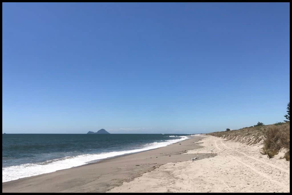
From here, too, you’ll be able to see across to White Island (Whakaari), the country’s most active volcano, which, as mentioned above, erupted in 2019 with devastating consequences. Something Extra: Head up Waiotahe Beach to the Te Ahiaua Reserve to collect pipis (shellfish) at low tide! You can take home 150 pipis – yum! Last Updated: May, 2026.
Whether you’re chasing surf, a swim, or just a sunny spot to relax, the Bay of Plenty really does deliver on these. With its absolute standout beaches along this stretch of coast, you could have the summer holiday of your dreams at any of these!